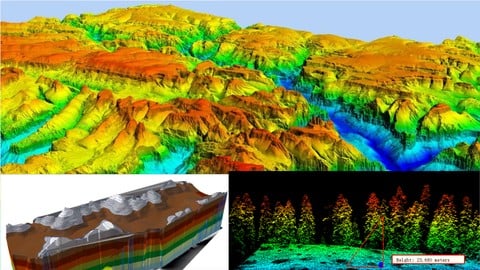
If you are searching for the GIS project related to elevation data, this course is definitely for made for you. In this course you will learn about the lots of project based idea such as drainage management, surface analysis using DEM, volume calculation for hydrological study, remote sensing analysis etc. You also get the change to learn about the LiDAR technique. At the completion of this course, you built your confident to working any of the Digital Elevation datasets.


Lorem ipsum dolor sit amet, consectetur adipiscing elit. Ut elit tellus, luctus nec ullamcorper mattis, pulvinar dapibus leo.
Lorem ipsum dolor sit amet, consectetur adipiscing elit. Ut elit tellus, luctus nec ullamcorper mattis, pulvinar dapibus leo.
Lorem ipsum dolor sit amet, consectetur adipiscing elit. Ut elit tellus, luctus nec ullamcorper mattis, pulvinar dapibus leo.