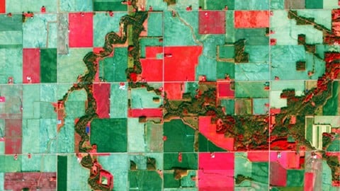
QGIS and Core Remote Sensing: Land Use/Land Cover Mapping Course
Are you looking to create a land use/land cover map for your project but unsure where to start? Traditional GIS resources not meeting your practical needs? Welcome to the QGIS and Core Remote Sensing course, designed to provide you with the knowledge and skills required for practical land use/land cover (LULC) mapping and change detection using popular and free GIS software tools, specifically QGIS. This 4.5-hour course is tailored to guide you through both the theoretical and practical aspects of LULC mapping and change detection, crucial skills for Geographic Information Systems (GIS) and Remote Sensing analysts.
Course Highlights:
-
Practical LULC mapping and change detection in QGIS
-
New QGIS version
-
Theoretical and practical background
-
Acquiring and processing Remote Sensing (satellite) data
-
Accuracy assessment
-
Classification algorithms
-
Creating change maps
-
Ideal for professionals in various fields
-
Hands-on exercises in QGIS
-
Downloadable practical materials
Course Focus:
This course provides comprehensive coverage of LULC mapping and change detection in QGIS, emphasizing both theoretical foundations and practical application. By course completion, you will have a solid understanding of LULC mapping and change detection in GIS and Remote Sensing and be proficient in performing these tasks using QGIS.
What You’ll Learn:
-
Installing open-source Remote Sensing and GIS software (QGIS) and configuration
-
Navigating QGIS software interface, including components and plug-ins
-
Classifying Remote Sensing (satellite) images using various machine learning algorithms in QGIS
-
Collecting training and validation data and conducting accuracy assessments
-
Performing change detection with the Semi-automated classification plug-in in QGIS
-
Preparing land cover change maps for reports
Who Should Enroll:
This course is ideal for professionals across diverse fields, including geographers, programmers, social scientists, geologists, Remote Sensing and GIS experts, and anyone needing LULC maps for their work. If you’re facing tasks requiring state-of-the-art classification algorithms for land cover and land use maps, this course will equip you with the necessary skills and confidence to tackle these geospatial challenges.
INCLUDED IN THE COURSE: Access downloadable practical materials, datasets, and step-by-step instructions for practical exercises in QGIS. Enroll today to take the first step in mastering LULC mapping and change detection!